- This topic has 0 replies, 1 voice, and was last updated 3 weeks, 5 days ago by
 chubes.
Log in to view. Or, click here to read the blog version of this post (with ads).
-
#48624| March 31, 2024 at 10:14 pmchubesHMFICRank: Frozen Foods IslePoints: 10442.75
What Would Happen If a Ship Hit the Ravenel Bridge?
Published: March 27, 2024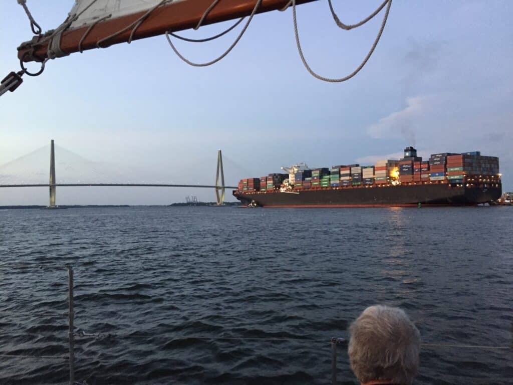
Taken from the Schooner Pride, dockside. Like most people today, I was shocked and saddened to hear the news about the Francis Scott Key Bridge collapse in Baltimore, after a container ship lost power and veered outside the shipping lanes. The incident was captured on security video, and you can clearly see the disaster unfold in real time.
From the ship losing power, to regaining it, to losing it again, and then colliding with the bridge followed by the immediate collapse of the bridge, it’s a jarring thing to watch.
Living in Charleston, we see ships go under the Arthur Ravenel Jr. Bridge every day. Our small coastal city has one of the busiest harbors on the east coast, and also one of the deepest.
This has led many people to wonder what would happen if Charleston experienced a similar scenario. Many of us drive over our that bridge every day, and some may have even driven over it at the very moment that a ship passed under.
We naturally want to take a look at our own bridges after an event like this. But before we get to the bridge itself, we have to look at the waterway leading up to it.
Looking at Charleston Harbor
As the former captain of the Schooner Pride, I’ve spent a lot of time navigating the waterways near the bridge, and my personal conclusion is that we’d be a lot less likely to experience such a disastrous bridge failure in Charleston due to both natural factors, and factors of engineering.
Below I’ve shared a screenshot depicting the relevant section of the nautical chart of Charleston Harbor, which may seem confusing to look at for many, but I’m going to explain it, so bear with me.
NOAA Chart 11524: Charleston Harbor
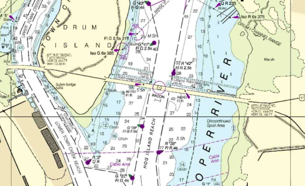
In the chart above, you are looking directly at the part of the harbor where the bridge goes over the Cooper River. The purple circle where it says “RACON” (a navigational aid) is the center span of the bridge where the ships pass under. The small numbers represent the depth of the water.
Most cargo ships that come into Charleston Harbor draw around 30-60 feet, depending on how loaded down they are. Based on those numbers alone, and looking at the chart, a ship pulling that same sideways drift maneuver as it approached the bridge is likely to get stuck in the mud rather than hit the bridge.
The bottom there is all pluff mud and it would just absorb the ship’s momentum and stop it in its tracks. Then, it would require several tug boats to get it moving again.
Not to mention, ships rarely, if ever, pass under the bridge without a tug being within 100 yards of the ship, ready for corrective action.
What If It’s Under the Bridge?
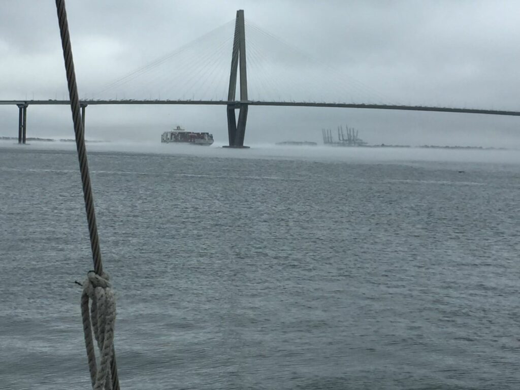
Also taken dockside from the Pride. This scenario is more complex, but it’s where nature hands the gloves to human engineering for the final round. When the Ravenel Bridge was built in 2005, it was to replace two older, rickety bridges that would have almost certainly collapsed in a similar fashion as the Francis Scott Key Bridge had they undergone a similar collision (and the Grace Memorial Bridge did, in 1946).
At the base of each main pillar of the Ravenel, there are pyramid-shaped rock piles that expand outward away from the bridge at the bottom of the harbor. Thousands of tons of rock that has been placed there specifically to stop a ship from hitting the bridge.
Even some engineers who worked on the bridge, including Don Hand of Thompson Construction, have spoken on this topic, even down to the concrete that was used for the rock piles. This quote comes from ABC News 15:
“The concrete was designed with a hundred-year life cycle,” Hand said. “There was a lot of stuff put into it from both chemicals and the matrix of the concrete that was put together to prevent salt intrusion and chloride ion penetration.”
So, while this scenario has thankfully never been tested, the scientific consensus is that this kind of disaster would be extremely unlikely to happen in Charleston. At least where the Ravenel Bridge is concerned.
What About the Don Holt?
Ah, yes, the Don Holt. On March 26th, the city confirmed that the Don Holt Bridge would be replaced as part of the I-526 widening project. The timing on that announcement will hopefully quell your fears, as ships do indeed pass under the Don Holt Bridge further up the Cooper River.
Opened in 1992, it’s much less a state-of-the-art bridge in its current condition and I would feel much less confident declaring it as safe from such a collision. However, it does have a similar situation with shallow water and/or land on either side of the channel leading up to it, so it poses less of a risk.
Let’s just hope they finish it quickly.
- You must be logged in to reply to this topic.
Users Currently Online: 0
Most Ever Online: 8 on 02/06/2024
Total Members: 180